The following article was commissioned by the Habitat Strategic Initiative Lead (HSIL), a cross-agency team co-led by the Washington Departments of Fish and Wildlife and Natural Resources.
Where are the best places to invest in restoration and protection of beach and riparian habitats? In this post we highlight three tools, funded by the Habitat Strategic Initiative Lead, built to help prioritize recovery actions. Each of these tools uses Geospatial Information Systems (GIS) to identify and prioritize areas for protection or restoration. One of the tools is regional in scope and has a user-friendly online interface. The two others focus on individual watersheds and, although they are not available for online exploration, are being used for local salmon recovery planning. Each of these tools assist in integrating data into habitat recovery planning processes.
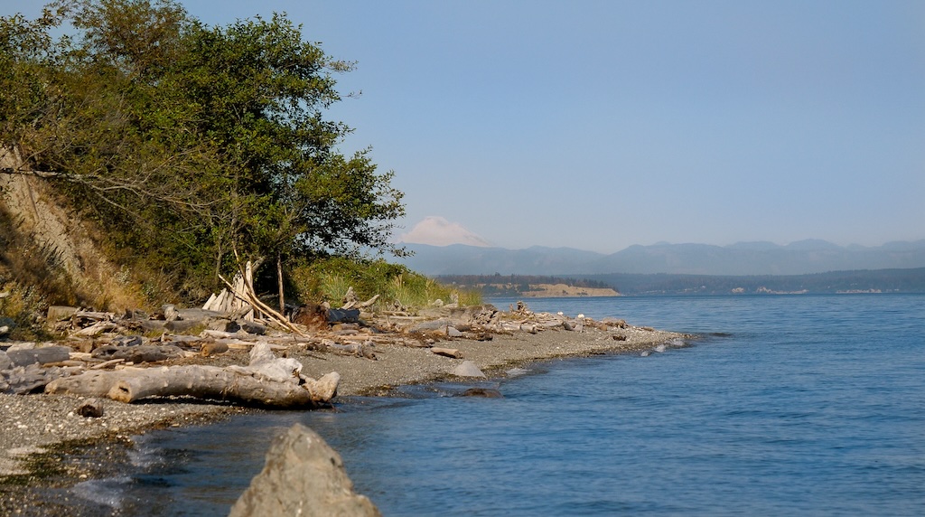
Beach Strategies for Nearshore Restoration and Protection
In 2023, the Washington Department of Fish and Wildlife Estuary and Salmon Restoration Program released the Beach Strategies for Nearshore Restoration and Protection web tool. This online interface is built on more than 10 years of data compilation and analysis efforts that began as part of the Puget Sound Nearshore Ecosystem Restoration Project. The cumulative result is a tool that provides restoration practitioners, planners, researchers, and educators with data and management recommendations for all marine shorelines in Puget Sound.
The Explore the Data page brings users to an interactive map that displays spatial data and calculated metrics reflecting nearshore process degradation and the potential benefit of restoration or protection. The Beach Strategies Data Exploration Tool allows users to download data associated with a specific query. Users can select a management priority (sediment supply, forage fish, pocket beaches), a restoration or protection management focus, and a spatial scale (Sound-wide, drift cell, shoreform, bluff). Results appear in pop-up windows that provide potential benefit metric values and an option for users to download a report. The Understanding the Results page describes the Beach Strategies analytical framework and provides information about how to use results.

Skagit Stream Shade Model
An important aspect for salmon recovery is ensuring that rivers and tributaries can support salmon spawning and that they provide food and shelter for the young. One aspect required by salmon, both young and old, is shade. Streamside trees and shrubs produce necessary shade to reduce stream temperatures.
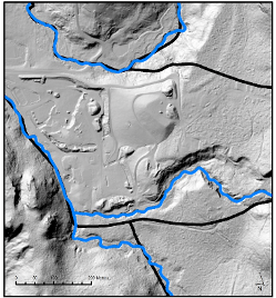
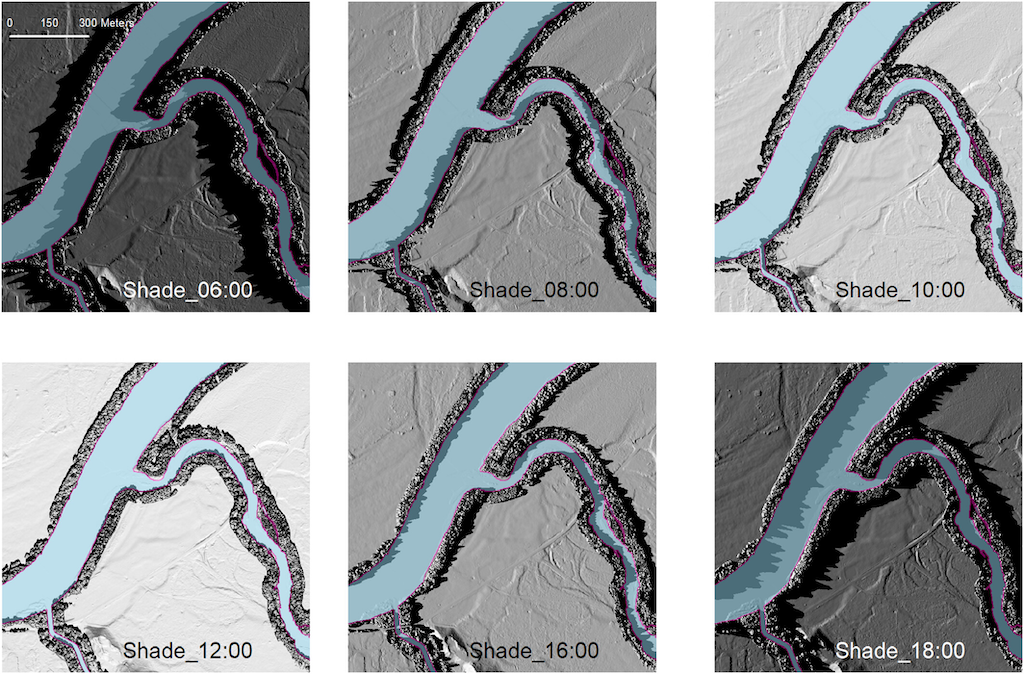
To better understand the current shade conditions in the Skagit Watershed and identify priority areas for riparian planting, the Skagit River System Cooperative created a Skagit Stream Shade Model. This model uses high-resolution LiDAR to depict current shade conditions and conditions 100-years in the future. The future predictions are based on how tall current trees will grow if undisturbed for 100 years. This data was retrieved from the Washington Department of Natural Resources digital site index maps.
To create the shade model, the project team first had to build a solid base map. The National Hydrographic Dataset (NHD) is the standard dataset used by state agencies in Washington to depict water attributes. The NHD is an excellent tool for regional hydrology, however locational errors can be found when focusing in on specific rivers, streams, or tributaries. To reduce these errors for their project, the Skagit River System Cooperative created their own hydrography layer. This was accomplished by combining the NHD with LiDAR data (a mapping process to measure and depict the earth’s surface using lasers). The resulting layer is called the Skagit lidar-derived hydrography layer.
The Skagit Stream Shade Model is built upon this new hydrography layer and provides insights on where to focus efforts to enhance shade for fish. By mapping and comparing the amount of shade a waterbody receives throughout the day in current conditions (as of 2016) and in future conditions (100 years in the future), the model can identify areas where planting trees are likely to have the greatest benefit for salmon. Outputs from the model can help to inform on restoration projects.
This project was developed with transferability to other watersheds in mind. Documentation detailing the hydrography layer and models so that the tool can be adapted for different regions is provided.
Riparian decision support system
A riparian decision support system was developed by the Puyallup and Chambers Watershed Salmon Recovery Lead Entity technical advisory group in Pierce County to support prioritizing restoration, protection, and monitoring of floodplain and riparian habitat.
The riparian decision support system was developed using a Bayesian network model, which is a tool that uses influence diagrams to estimate the likelihood that a factor will impact an outcome of interest. In this instance the outcome of interest is riparian habitat at the Puyallup catchment level. The Bayesian network model was developed using empirical data and expert knowledge to inform the selection and valuation of model variables known to influence habitat conditions and functions in the Puyallup Watershed.
With support from expert reviewers, the model was calibrated to include a series of environmental indicators and factors. There are three main indicators within the model: (1) habitat function, (2) habitat conditions, and (3) stressors. For each indicator there are then multiple contributing factors. For example, the factors for habitat function include amount of a floodplain, road density, proportion of floodplain disconnected, and human development impact to floodplain. These three indicators together with their environmental factors provide an index of watershed health at the catchment level.
When these indicators are added, the resulting score can indicate what types of restoration or protection activities would be most effective across the watershed, while providing a sensitivity analysis delineating which variables might have the greatest influence on the overall catchment index score. This suite of information can be used by decision-makers to prioritize and focus limited resources towards specific activities.
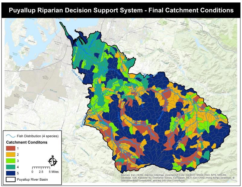
Credit: Puyallup Watershed Riparian Decision Support System.
- Developing Strategies and Accompanying Web Tool for Science-Based Beach Restoration and Protection – NTA 2018-0582
- North Sound Riparian Modeling and Monitoring – NTA 2018-0167
- Tim Hyatt. 2022. A lidar-based assessment of riparian shade and large wood potential in the Skagit River watershed, WA. Journal of American Water Resources Association. https://doi.org/10.1111/1752-1688.13099
- Methods for making the Skagit lidar-derived hydrography.
- Datasets for the Skagit Stream Shade and Wood Recruitment Models:
- Riparian / Land Cover Change Decision Tool – NTA 2018-0636
- Pierce County website with model documents including instructional schematics, data documents, and reports.
The 2012-2013 Action Agenda for Puget Sound developed by the Puget Sound Partnership established three initiatives to tackle multiple issues critical to Puget Sound recovery:
- habitat protection and restoration
- shellfish bed protection and recovery
- stormwater pollution prevention
To manage this effort, agency and institutional partners assembled into three Strategic Initiative Lead (SIL) teams, charged with bringing people and ideas together to improve the water, habitat, and communities. Read more about the Puget Sound Recovery Program.
The role of HSIL is to implement plans that improve the health of the rivers, forests, shorelines, and estuaries that make up Puget Sound.
This article has been funded wholly or in part by the United States Environmental Protection Agency under assistance agreement PC-01J22301 through the Washington Department of Fish and Wildlife. The contents of this document do not necessarily reflect the views and policies of the Environmental Protection Agency or the Washington Department of Fish and Wildlife, nor does mention of trade names or commercial products constitute endorsement or recommendation for use.