The following article was commissioned by the Habitat Strategic Initiative Lead (HSIL), a cross-agency team co-led by the Washington Departments of Fish and Wildlife and Natural Resources.
Do you work with local environmental regulations? Would you like to improve habitat protection through more effective permitting? This overview can help if you are thinking about responding to an upcoming funding opportunity from the Department in Commerce, in collaboration with the Habitat Strategic Initiative Lead, for local jurisdictions to develop monitoring and adaptive management processes for their critical area ordinances.
| The Habitat Strategic Initiative Lead (SIL) announced 2023 investment priorities in the joint SIL 2023 Investment Plan released on October 12, 2023. Habitat SIL Investment Priority B allotted up to $2 million for local jurisdictions to implement the Washington Department of Commerce’s Critical Areas Handbook – Chapter 7 Monitoring and Adaptive Management of Critical Areas. The Request for Proposals for Priority B is expected to be released in April 2024. There is no match requirement. |
This post includes a broad overview of Chapter 7 from the Critical Areas Handbook; describes resources available to help jurisdictions with permit implementation and effectiveness monitoring; and provides some examples from Kitsap County’s monitoring and adaptive management program. We hope this information inspires you to launch or expand monitoring and adaptive management activities in your jurisdiction.
Washington State Department of Commerce Puget Sound critical areas monitoring and adaptive management project
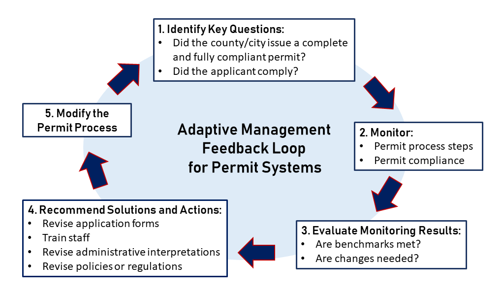
Knowing whether regulations and permit procedures are protecting critical areas and shorelines requires monitoring of the permit process and on-the-ground results. If monitoring uncovers problems, changes can be made to address them. Learning from monitoring results and adjusting practices as new information becomes available are at the heart of adaptive management. As illustrated in the figure below, Chapter 7 outlines five steps in the permit system monitoring and adaptive management process: 1) identify key questions, 2) collect monitoring data relevant to the questions, 3) evaluate monitoring results, 4) recommend solutions and actions, and 5) modify the permit process.
An updated version of Chapter 7 was published in 2023 with funding support from Habitat SIL. It now provides more detailed instructions for each step of the process; additional training on key topics like no net loss; information about state agency data resources; and tips on developing systems to track monitoring metrics. New appendices to Chapter 7 include case studies from local monitoring and adaptive management programs, model ordinance language, and tools (e.g., templates, checklists) developed by local governments.
Another resource developed with funding from Habitat SIL is the Critical Areas Monitoring and Adaptive Management Training website. In 2021, the Washington Departments of Commerce, Fish and Wildlife, and Ecology hosted an 11-week webinar series for local planners. Presenters included experts from state agencies as well as staff from local jurisdictions who shared information about their monitoring and adaptive management efforts. Video recordings of the webinars, presentation slide decks, handouts, and tools developed by local governments are available on the project website.
Kitsap County effectiveness monitoring of regulations regarding shoreline, critical areas, and stormwater requirements project
This Habitat SIL funded project provides an example of how to implement two of the steps described in Chapter 7. It began in 2019 and started with Step 5 of the feedback loop because it built off an earlier shoreline permit monitoring project that completed Steps 1-4 in 2015. Since adaptive management is an iterative process, once those improvements were made the project team began again at Step 1. There were three distinct project elements:
SmartGov system updates (Step 5)
Monitoring results from 2015 indicated that there was too little searchable data in Kitsap County’s SmartGov electronic permit processing and tracking software. To address this deficiency, the project team created electronic checklists to document conditions of permit approval in a way that makes them easy to query. These electronic checklists allow staff to tag permits with critical area features in the project area and permits requiring stormwater best management practices. By using a simple questionnaire, the checklist can capture information typically embedded in PDF reports submitted with permit applications. This new system, completed in 2020, improves data accessibility and acquisition of monitoring data by allowing staff to easily query information on permits with critical area or stormwater requirements. Customizing SmartGov software can be challenging, but the solutions developed by Kitsap County may be informative for other jurisdictions that use the system.
New monitoring permit (Step 5)
Another issue noted in 2015 was a lack of staff follow-up on permits with long-term mitigation requirements. The SmartGov system did not have an automated process for reminding permittees of reporting requirements and, because permit fees were generally spent once the permit was issued, there was no funding left for staff to follow-up. To fix this problem, the project team created a new permit type in SmartGov that automates annual tracking of permits that require multi-year mitigation monitoring plans. The new monitoring permit sends reminders to permittees about annual reporting requirements and funds staff time to follow-up on mitigation conditions. As of January 1, 2023, all applicants with permits that include a mitigation and monitoring plan are required to pay the monitoring permit fee, record a monitoring covenant with Kitsap County, and submit annual monitoring reports.
New monitoring plan (Step 1)
Kitsap County also developed a new Critical Areas Ordinance and Shoreline Master Program effectiveness monitoring plan. As illustrated in the figure, the plan identifies key questions and specific metrics to answer them. The monitoring metrics were designed to use utilized pre-configured High Resolution Change Detection data products to reduce technical barriers. The two landscape scale evaluation metrics Kitsap County selected came from a 2021 Washington Department of Fish and Wildlife critical area ordinance effectiveness project funded by Habitat SIL.
| Monitoring questions | Evaluation metrics | |
|---|---|---|
| Five implementation monitoring questions to evaluate the consistency and completeness of issued permits against state and local regulations | answered by >> | Four site scale monitoring metrics to determine if observed changes were subject to permit review and, if so, were consistent with permit conditions |
| Three effectiveness monitoring questions to evaluate how permit provisions are working by assessing changes in the condition of critical areas | answered by >> | Two landscape scale monitoring metrics to quantify vegetation changes inside and outside of critical areas and shoreline buffer zones |
The plan also outlines how monitoring results should be used to support future code updates. The next task is to define the monitoring metric thresholds that would trigger adaptive management actions, such as increasing staff training. Kitsap County plans to conduct shoreline monitoring in 2024-2025 to inform its 2026-2028 Shoreline Master Program update, and critical areas monitoring in 2030 to inform the 2030-2032 Comprehensive Plan update.
Jurisdictions interested in setting up a similar monitoring project should keep an eye out for RFPs from the Habitat Strategic Initiative Lead in April 2024.
- Puget Sound Critical Areas Monitoring and Adaptive Management Program – NTA 2018-0327
- Effectiveness Monitoring of regulations regarding shoreline, critical areas, and stormwater requirements – NTA 2018-0713
- Enhancing Critical Area Ordinance Effectiveness via Adaptive Management – NTA 2016-0368
- Completing High Resolution Change Detection 2015 with Land Cover – NTA 2016-0141
The 2012-2013 Action Agenda for Puget Sound developed by the Puget Sound Partnership established three initiatives to tackle multiple issues critical to Puget Sound recovery:
- habitat protection and restoration
- shellfish bed protection and recovery
- stormwater pollution prevention
To manage this effort, agency and institutional partners assembled into three Strategic Initiative Lead (SIL) teams, charged with bringing people and ideas together to improve the water, habitat, and communities. Read more about the Puget Sound Recovery Program.
The role of HSIL is to implement plans that improve the health of the rivers, forests, shorelines, and estuaries that make up Puget Sound.
This article has been funded wholly or in part by the United States Environmental Protection Agency under assistance agreement PC-01J22301 through the Washington Department of Fish and Wildlife. The contents of this document do not necessarily reflect the views and policies of the Environmental Protection Agency or the Washington Department of Fish and Wildlife, nor does mention of trade names or commercial products constitute endorsement or recommendation for use.