What is the largest estuary in the United States? This is a question loaded with confusion and open to interpretation, as you will soon see. Before we get to the likely answer — which may surprise you — let me share a few authoritative views on the subject:
Chesapeake Bay Foundation: “Chesapeake Bay is the largest estuary in the United States and the third largest in the world. It is about 200 miles long and holds more than 18 trillion gallons of water.”
U.S. Rep. Derek Kilmer of Washington state: “Puget Sound (is) the nation’s largest estuary by volume and the heart of Washington state’s identity and economic engine.”
National Ocean Service (NOAA): The Chesapeake Bay is the largest estuary in the United States and one of the most productive bodies of water in the world. The Chesapeake watershed spans 165,759 kilometers (64,000 miles), covering parts of six states: Delaware, Maryland, New York, Pennsylvania, Virginia, West Virginia and the District of Columbia.”
I could go on and on, quoting news media, government leaders, agencies, non-profit groups and others, not to mention the New York Times Crossword Puzzle. Chesapeake Bay is widely seen as the largest estuary in the United States, and Puget Sound is often mentioned as the second-largest — or sometimes the largest estuary by volume, since Puget Sound is much deeper than the Chesapeake. Others high on some lists are San Francisco Bay and the Albemarle-Pamlica estuary in North Carolina.
Totally forgotten, it seems, is an estuary located in an out-of-the-way place, an estuary that turns out to be larger than any of the better-known U.S. waterways in more than one way.
An estuary, you might recall, is a “partially enclosed, coastal water body where freshwater from rivers and streams mixes with salt water from the ocean,” as defined by the Environmental Protection Agency.
In deciding which estuary gets first position, I have learned that one can measure the size in at least four ways. The area covered by water seems the most logical, but you can also talk about the volume of water contained within the estuary. Some people like to describe an estuary by the length of its shoreline. Others refer to the size of an estuary’s watershed, which is the total land area drained by all the rivers and streams that flow into the estuary.
Are you ready for some numbers? Chesapeake Bay weighs in with a surface area of 4,480 square miles, according to the Chesapeake Bay Commission (PDF 493 kb). Puget Sound, as defined by oceanographers, is less than one fourth that size at 1,016 square miles (Encyclopedia of Puget Sound). Puget Sound is a little smaller than San Francisco Bay, which covers 1,600 square miles (EPA). [Editor’s note: There are inconsistencies in the way people define the geographic boundaries of Puget Sound, but for the purposes of this article, we defer to boundaries determined by oceanographers.] The Albemarle-Pamlico National Estuary Partnership boasts of more than 3,000 square miles of estuarine waters in North Carolina, although the boundaries of that waterway are not so easy to define.
The estuary that nobody is talking about is Alaska’s Cook Inlet, which has a surface area of 7,930 square miles —close to double the size of Chesapeake Bay, as confirmed by bathymetric surveys of the Alaskan waterway (summary sheet along with full report).
Mark Zimmermann, an expert in geographic information systems at NOAA’s Alaska Fisheries Science Center, stitched together extensive data from dozens of bathymetric surveys to come up with the size of Cook Inlet, as measured in various ways.
“I didn’t have any preconceived notions about the area or volume, but it is interesting that Cook Inlet isn’t really thought of as a big estuary,” Mark said. “Areas like San Francisco Bay and Chesapeake Bay may be famous because they are near big cities. People really should know Cook Inlet, which happens to be near Anchorage, Alaska’s largest city.”
In fact, Cook Inlet, which is “partially enclosed” — as the EPA definition of estuary requires — may not be the largest estuary if one relaxes the definition to allow more open-water mixtures of freshwater. Norton Sound, which lies to the northwest of Cook Inlet, is an even bigger estuary by that relaxed definition used by some authorities. Alaska has other large coastal bodies of water as well. The “classic definition” of estuary used by EPA dates back to 1952 and is attributed to an oceanographer who studied Chesapeake Bay, according to Michael Fincham in Chesapeake Quarterly.
I am not sure why Cook Inlet was forgotten in the discussion of the largest estuaries in the United States. Is it because the state of Alaska is separated from the rest of the country and thus fairly easy to forget?
Kris Holderied, a physical oceanographer with the NOAA’s National Ocean Service, made her way from Washington, D.C., to Homer, Alaska, arriving in 2005 to work on coastal ecosystem challenges. It was her first time in Alaska.
“You don’t hear too many news reports about Alaska in the Lower 48,” Kris said. “Some people may forget that there is a state farther up north. I have a friend whose strong suit is not geography or looking at maps. She thought Alaska was an island.”
Those who think that Alaska is an island can blame mapmakers for their depiction of the United States. After drawing the 48 contiguous states, they often stick Alaska and Hawaii into a convenient spot on their map — generally out in the Pacific Ocean, nowhere near their actual locations.
Speaking of maps, not everyone realizes that a Mercator projection of North America greatly distorts the apparent size of land masses to the north, including Alaska, Greenland and so on. This is the result of trying to project a spherical Earth onto a flat piece of paper or computer screen. Close to the equator, things look OK. But as you go farther north the distortions make the land masses look bigger and bigger.
Not that Alaska needs any exaggeration when it comes to size. Alaska is a very large state, greater in size than the next three — Texas, California and Montana — combined. In fact, if Alaska were divided into two states of equal size, both of the new states would be larger than Texas.
Long before she came to Alaska, Kris felt at home on Chesapeake Bay, having grown up in Connecticut and Maryland and eventually attending the U.S. Naval Academy, where she became an oceanographer with a focus on the Chesapeake. “You might say Chesapeake Bay is part of my DNA,” she noted. In 2000, she switched jobs from the Army Corps to the National Oceanic and Atmospheric Administration and soon received an assignment to study water quality, melting glaciers and ocean acidification in our most northern state.
“This is a super-interesting place for a physical oceanographer to work,” she told me, referring to her work in Cook Inlet and other Alaskan waterways. “It’s a mix of fresh and salt water. The most interesting thing is that these waterways are a lot deeper.”
The state of Alaska is surrounded by water on three sides. Like Puget Sound, many of the waterways were carved out by glaciers in ancient times. Being farther north than Puget Sound, the tides are even more extreme, with high tides as much as 33 feet above low tide. So when you are talking about the size of an estuary in Alaska, you must first ask a basic question: “Are you measuring the estuary during a high tide or a low tide?”
As for Mark’s measurements of Cook Inlet, the surface area of 7,930 square miles was calculated at the average high tide. When the tide drops to an average low tide, the surface is reduced to 7,307 square miles, with 7.9 percent of the area becoming exposed shoreline. Since Chesapeake Bay does not fluctuate much, the 4,480-square-mile figure is a pretty good estimate during any tidal period. Puget Sound’s surface area of 1,016 square miles varies somewhat with the tides.
Although Puget Sound is deep — up to 938 feet — the claim that Puget Sound is the largest estuary by volume does not hold up against Cook Inlet because of the inlet’s vast area. Compared to Puget Sound’s volume of 40.3 cubic miles, Cook Inlet holds about 246.7 cubic miles of water, while Chesapeake Bay’s volume is less than 16 cubic miles.
Puget Sound is deeper, since Cook Inlet’s deepest spot is about 695 feet, and Chesapeake Bay’s deepest hole is 174 feet deep. For their average depth, Puget Sound is about 230 feet, Cook Inlet is 147 feet and Chesapeake Bay is 21 feet.
In terms of watershed (the land area that drains into the waterway), Chesapeake Bay comes out on top. Chesapeake Bay’s watershed spans some 64,000 square miles, with 39,000 square miles for Cook Inlet and 13,700 square miles for Puget Sound (PS Watershed Characterization).
This 13,700 square miles for Puget Sound is based on the statutory definition of Puget Sound, which includes the Strait of Juan de Fuca and the San Juan Islands to the Canadian border. I have been unable to find bathymetric measurements that fit this larger definition, so I used the traditional oceanographic definition of Puget Sound.
I cannot leave this subject of “largest estuary” without recognizing that Puget Sound is just the southern portion of a larger estuary called the Salish Sea. If the debate is expanded beyond the United States to all of North America, then we must talk about the entire Salish Sea, which extends into Canada. In fact, the Canadian portion of the waterway, often called Georgia Strait, is much larger than Puget Sound.
Let’s look at the sizes again. The surface area of the Salish Sea is about 6,590 square miles, nearly as large as Cook Inlet’s 7,900 and bigger than Chesapeake Bay’s 4,480. (Separate figures published by the SeaDoc Society and Salish Sea Atlas are close estimates.) I have not yet found reliable numbers for the volume or watershed area of the entire Salish Sea.
To be fair, a search for the largest estuary in North America must include a waterway on the east coast of Canada called the St. Lawrence Estuary, which many experts call the largest estuary in the world. Its actual surface area is subject to debate because its open waters adjoin the much larger Gulf of St. Lawrence.
Cook Inlet, by the way, was named after Capt. James Cook, the first British explorer to sail along the Northwest Coast during an expedition in 1778. Capt. George Vancouver, who served under Cook, was the one who named the inlet in 1794 during a later expedition that he led. In 1792, Vancouver also named Puget Sound in honor of Lt. Peter Puget, who accompanied him on the expedition. At the time, the name only applied to the very southern portion of what is now called Puget Sound.
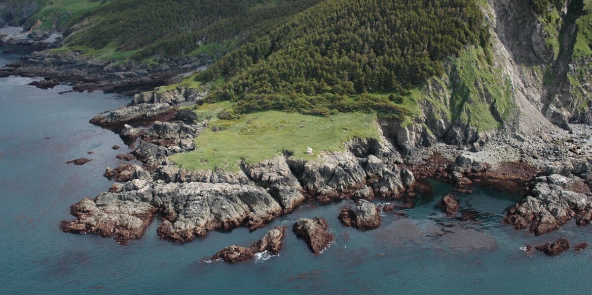
Elizabeth Island at the entrance to Cook Inlet (shown in the top photo on this page) was first named “Cape Elizabeth” by Cook, who did not realize that the point was on an island, according to CoastView, an education program. The name was later changed during mapping by the U.S. Coast and Geodetic Survey. The island’s name recognizes Princess Elizabeth, the seventh child of King George III, who reigned over Great Britain and Ireland from 1760 to 1820.
Good discussion and very clear comparison. Thanks.