The Puget Sound Institute is launching a new program that will use supercomputers to advance ecosystem recovery of the Salish Sea. The Salish Sea Modeling Center will allow scientists from around the region to access sophisticated computer models to predict changes in the ecosystem. Work at the center will tackle vexing environmental problems such as the changing chemistry of the Salish Sea and other mysteries puzzling scientists. The center is supported by the Environmental Protection Agency and other regional water quality partners.
If you want to understand where fish or killer whales go, or how toxic chemicals move through the ecosystem, it helps to know how the water moves. The ebb and flow of currents is fundamental to scientific efforts to protect and restore the Salish Sea.
Researchers have known for many years that they could create physical models to simulate the movements of these currents. In the 1950s, engineers created scale replicas out of concrete that used saltwater and colored dye to track the motion of processes like tidal flows and circulation. These scale models were a standard for oceanographers for more than 30 years.
Now, computer models can replace circulating dye and water pumps with just about any conceivable data. They can reveal how water temperature changes, how fast Arctic melting will raise the tideline along the shore, or when global carbon emissions will eventually turn the Salish Sea acidic. They can anticipate herring spawns or answer policy questions about where and how to clean up toxic chemicals.
Providing the region’s policy leaders and scientists with these powerful tools is the goal of the Salish Sea Modeling Center, a new enterprise from the University of Washington Puget Sound Institute. The center will initially focus on expanding the capabilities of the Salish Sea Model, an advanced computer simulator developed over the past decade. The Salish Sea Model accurately describes how water, sediments, and nutrients enter and cycle through the Salish Sea, and is widely used by resource and regulatory agencies in the region. The model was developed by Dr. Tarang Khangaonkar and his team at the U.S. Department of Energy’s Pacific Northwest National Laboratory (PNNL). The work was done in collaboration with the Washington State Department of Ecology with grant support from the Environmental Protection Agency. Khangaonkar, who is both a principal program manager at PNNL and an affiliate professor at the University of Washington Tacoma, will serve as director of the Salish Sea Modeling Center. Support for the new center is provided by the Environmental Protection Agency’s National Estuary Program and other regional water quality partners.
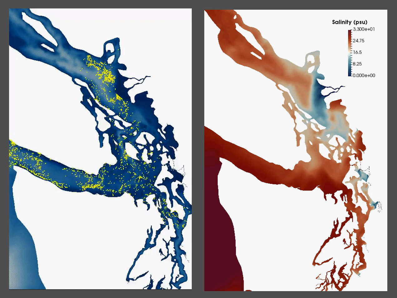
“This is perhaps the first model of the entire Salish Sea that was built specifically for supporting ecosystem restoration and water quality management,” according to Khangaonkar, who says the massive, cross-border ecosystem posed significant challenges for developers during the early efforts. The Salish Sea’s 4600 miles of winding shoreline and its deep, underwater canyons, sills, and numerous islands were far too complex for conventional and commercially available models used in coastal applications at the time. “Computational challenges are particularly hard for our fjord-like estuary with its complex features,” says Khangaonkar. “In addition, the model must take into account runoff from 161 different watersheds, and wastewater load from nearly 100 outfalls from an ever-growing population along the shoreline.”
To capture these complexities, the model runs on a modified supercomputer consisting of up to 384 processors working in parallel (“like many desktop computers all working together,” Khangaonkar says). The result is a predictive tool that is already being applied to critical policy questions in the region. In recent years, the Washington State Department of Ecology began using the model to understand how nutrients from wastewater might be diminishing Puget Sound’s water quality. That work led to ongoing discussions about the future of the region’s wastewater treatment plants, and the model has been at the center of policy debates that could affect hundreds of millions of dollars in treatment plant retrofits.
But the model has quickly become a framework for probing many other scientific questions. Its open source software is designed to be used by anyone, and scientists from many different disciplines are now plugging in their data.
“Work at the center will focus on the use of the model to take on other issues of regional importance,” says Dr. Joel Baker, director of the Puget Sound Institute. “It allows a really well-designed and well-built model to be more widely used. We can now bring critical questions from policymakers back to the scientific community and ask, ‘Can you model this?’”

One such question concerns the fate of toxic PCBs in Puget Sound. Scientists have noted that levels of PCBs have remained relatively constant in parts of the food web, despite efforts to remove them from sediments on the seafloor. Some theorize that legacy PCBs are entering Puget Sound through stormwater and are being cycled through the estuary without settling to the bottom. Puget Sound Institute scientists and their collaborators at the Washington Department of Fish and Wildlife are using simulations of the Salish Sea Model to better understand how important contaminants are moving throughout the Salish Sea.
“If it turns out this is true, just cleaning up the sediments may not fix the problem,” says Puget Sound Institute research scientist Andy James, one of the principal investigators on the project. Knowing how toxic contaminants move through the system could help policymakers identify the best places to focus their cleanup efforts, potentially reducing the amounts of harmful chemicals in fish that humans eat such as salmon.
Other mysteries currently being addressed by the model include the short-term effects of ocean warming on giant Pacific octopus populations, predictions of sea level rise impacts on estuary restoration, and the potential ways that eelgrass might offset ocean acidification.
In addition to its work with the Salish Sea Model, the center will also work with other organizations to combine information from computer simulations such as NOAA’s Atlantis food web model, EPA’s VELMA watershed model, or the University of Washington’s LiveOcean model which addresses water flow into the Salish Sea through the California Current.